Danny McGill:-
Coal-mining along the Ballycastle foreshore has been going on for hundreds if not thousands of years. McCahan1 in his “Local Histories” writes of the probability of Phoenician traders taking coal from exposed seams here as far back as 300 B.C., with the Spaniards mining this coal much later to use in smelting silver and tin. He also recounts the story of the discovery of ancient mine workings by miners in 1770, who broke into an existing system of chambers and pillared galleries, where they found remains of baskets, iron-tipped tools and stone hammer-heads.
Further evidence of trading along this shore is evidenced in the list of port-names from Port Watty, east of the Pans Rocks; Murray’s Port, just past the Coalyard cottage; Port na Gree and Port na Loub, either side of Carrickmore Port. There are many others beyond Fair Head and more still to the west of Ballycastle, beginning with Port Brittas at the Quay.
With so many clues to the location of piers or jetties, Danny Morgan and I have been trying to find evidence of their existence e.g. steps cut into the rock, post-holes or even slipways or channels. Apart from Carrickmore Port and the much later Ballyvoy Pier (the iron staging), there is little evidence of any works on the shore except in two places viz. Coyles’ Rock and the Coalyard Cottage at the end of the shore road.
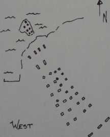
Both these sites contain an extensive matrix of post-holes cut into the living sandstone and these when plotted show that there stood at both sites wooden piers approximately fifty yards long and two to three yards wide. Most of the post-holes are twelve to fifteen inches square; some of those at the Coalyard site are larger and some are rectangular. Neither of these piers are recorded on any maps which we have seen and no one in the local community seems to be aware of their existence. There is no reference to a pier in the deeds of the Coalyard Cottage and we have yet to discover the reason for the name “Coyles’ Rock”.
The layout of the pier at Coyles’ Rock is a straightforward set of post-holes in pairs five feet apart, starting at a gap in the wall alongside the road. The pairs of holes are cut in a north-westerly direction, terminating at the edge of the rock, in a set of four oblong holes nine feet apart; beyond this there is another rock upon which are cut a further seven holes. This layout suggests to me that there was a pier or jetty built across the foreshore to the edge of the sandstone shelf, where a wider pierhead was joined to a smaller platform by a bridge, thus giving access to deep water. The secdnd set of holes running alongside the main set on the east side were, I think, added at a later date; the manner in which the outermost holes appear closer together would suggest the existence of a double-width pier for most of its fifty yard length.
The pier at the Coalyard Cottage, although of similar length to that at Coyles’ rock was much more substantial. At the shore end against the garden wall there are post-holes on the natural stone platform. This suggests that there was a wooden platform with steps leading up to the roadway level in two places (both built into the roadside wall but still identifiable) and a further set of wider steps cut into the rock on the western side leading from the platform to the roadway.
From this wooden platform thirty feet across, two piers ran out across the sandstone shelf (which is under water at high tide) to another, also thirty feet across, forming a pierhead at the water’s edge. This construction would have provided a complete circuit, six feet wide, allowing considerable activity on the pier involving the loading of salt and coal boats using wheelbarrows or possibly trolleys on a simple tramway of planks similar to that used in some of the mines after 1720.
Wilson writes: ‘boards were laid for running wagons (in the adits)’ 2. An extensive system of wagon-ways was used by Boyd to bring stone for the building of his harbour in 17403 and his plan of the harbour dated 1743 shows a wagon-way from the coalmines.4
I was able to observe both pier locations from a small boat at low tide, courtesy of John Humphries of Ballycastle, who brought me out on a fine afternoon to see how they could have been approached from the sea. Even at low tide there was nine feet of water at the coalyard pier and both locations were freely accessible from the sea. It is worth noting that the North Star Dyke was also approachable that same afternoon, thus confirming my suspicions that it too could have been used to load small boats at any state of the tide. A few days later we marked each post-hole at the Coalyard Pier with a stick and white paper flag and photographed this from the cliff above. There was considerable excitement at finally viewing the outline of this old pier which probably had not been seen for more than one hundred years.
I believe both piers to have been erected close to the coalmines in the early 1700s when coal production was on the increase and there was considerable export to Dublin and other parts of Ireland.5
The expansion of the coal industry brought about an industrial boom with salt-making, iron-ore smelting, kelp-burning and lime-burning and this encouraged Boyd, who had been involved in the collieries from 1723 6, to build a new harbour at Ballycastle.7 The wagon-ways continued to be used in carrying coals to the new harbour but it is likely that the wooden piers fell into disuse soon after 1750.
Sadly Boyd’s industries, which included glassmaking8, came to an end thirty years after his death and the harbour, of which he was so proud became silted up and a hazard to shipping, much to the disgust of the merchants of Ballycastle.9
|
|
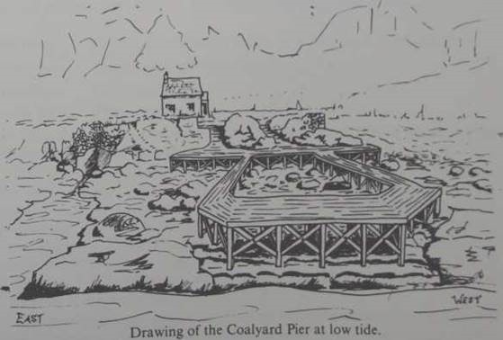
Currently there are a considerable number of man-made ramps, grooves and basins to the west of both pier sites; one at Coyles’ Rock is large enough for boats but not easily accessible from the sea. This is my impression of how the pier would have looked, based on the positions of the post-holes and my photographs of the site with the post-holes flagged.10
Note that there is a set of steps under the end of the pier and an inlet cut into the eastern side where there may have been a smaller platform. The square-cut rock-face I have drawn at the shore-end of the inlet is the site of one of the Petty salt pans mentioned in other articles in ‘The Glynns’11 12.
References:
1. Dallat, Cahal (Compiler), “McCahan’s Local Histories”, Glens of Antrim Historical Society 1988. p.4.
2. Wilson, George: “The Rise and Decline of the Ballycastle Coalfield”. Unpublished M.A. Thesis Queen’s University, Belfast, p.65.
3. Wilson, G. ibid. p.69.
4. Dallat, Cahal: “Ballycastle’s 18th Century Industries”: in ‘The Glynns’, Vol. 3 1975, pp. 9—13.
5. McCahan op.cit. and Wilson op.cit. detail the expansion of the coal industry at this period.
6. McCahan op.cit. p.4.
7. Boyd, Hugh: “Account of the progress of Ballycastle Harbour”. Dublin 1743 reprinted in ‘The Glynns’ Vol. 9 1981, pp.5—15.
8. Dallat, Cahal: “Ballycastle’s Glass Industry” in ‘The Glynns’, Vol. 2, pp.28—32.
9. See also the “Petition of the Merchants and Inhabitants of Ballycastle to His Excellency Philip, Earl of Hard wicke, Lord Lieutenant General and General Governor of that part of the United Kingdom of Great Britain and Ireland called Ireland.” Reprinted in ‘The Glynns’, Vol. 10,1982, pp.54—57.
10. Wilson, G. op.cit. The drawing of a bridge across the river Margy shows uprights twenty feet apart and braced diagonally. This leads me to assume that both the piers mentioned would have been built in a similar manner.
11. Dallat, C. op.cit. Vol. 3, p.9.
12. McGill, Danny: “Early Salt-making in the Ballycastle District” in ‘The Glynns’ Vol. 16,1988,, p.17
|
Post Holes At Coyle’s Rock Length 50 Yards Overall |